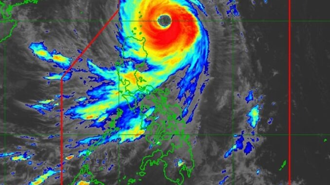
Ameteorologist has pointed out the sheer size of Typhoon Kong-rey’s eye as the massive storm approached Taiwan on Wednesday.
As of Wednesday afternoon, Typhoon Kong-rey had maximum sustained winds of 130 mph, according to the website Zoom Earth. The storm has weakened slightly since Tuesday night, when it was categorized as a super typhoon with maximum sustained winds of 150 mph, equivalent to a Category 4 hurricane. Forecasts anticipate that Typhoon Kong-rey will weaken further by the time it makes landfall in Kaohsiung in the early morning hours on Thursday.
On Tuesday night, meteorologist Noah Bergren of TV station WOFL in Orlando, Florida, commented on the size of the storm’s eye.
“Super Typhoon Kong-rey is easily one of the largest eye’s in a major tropical system you will ever see on Earth,” Bergren posted on X (formerly Twitter). “Thing is absolutely massive.”
A wave crashes outside of Fugang Harbor in Taitung, Taiwan, ahead of Typhoon Kong-rey on Wednesday. The storm is expected to make landfall in Taiwan early Thursday morning. Annabelle Chih/Getty
AccuWeather senior meteorologist Alan Reppert told Newsweek that having a large eye doesn’t necessarily imply anything about the storm’s strength.
“It just means the winds with it are farther away from the center than if it was a smaller eye,” he said. “It doesn’t necessarily have any major defining characteristic of the storm.”
Reppert added that a stronger storm that’s been around longer usually has a wider eye than a newer storm.
Most spaghetti models—or computer models illustrating potential storm paths—show Kong-rey making landfall on Taiwan’s southeast coast and cutting across the island before emerging with maximum sustained winds of around 75 mph. Models indicate that the typhoon will exhibit a northeastern turn away from China, which will take it out to the East China Sea.
Kong-rey’s strength is uncharacteristic for this time of year, The New York Times reported, adding that the typhoon is expected to make landfall equivalent to a Category 4 hurricane.
Reppert warned that strong winds up to 140 mph with higher gusts could hit southern Taiwan, though the storm is expected to weaken as it moves over the island. An AccuWeather report warned of “significant structural damage, mudslides and landslides” from the storm, as up to 3 feet of rain is expected to lash Taiwan. The storm could either maintain its intensity or strengthen before it makes landfall early Thursday.
Eastern China and Japan also are expecting heavy rain as the storm progresses.
A typhoon is classified as a severe tropical cyclone occurring in the Northwest Pacific. A hurricane is the term for the same type of storm in the Northeast Pacific and Northern Atlantic. Outside of these regions, the storms are called tropical cyclones.
Your Body Warns You: 7 Signs to Watch for a Month Before a Heart Attack
In today’s fast-paced world, stress and unhealthy lifestyles have become common, increasing the risk of serious health issues. Many people rely on fast food, struggle with maintaining a healthy weight, and face obesity, all of which can contribute to heart disease.
Heart attacks are the leading cause of death in America, but did you know that your body may warn you weeks in advance? Recognizing these signs early could save your life.
Here are seven key symptoms to watch for:
1. Extreme Fatigue
Feeling unusually tired, weak, or drained—especially without a clear reason—can indicate reduced blood flow to the heart due to narrowed arteries. Persistent fatigue may be an early warning sign of heart trouble.

2. Shortness of Breath
When your heart isn’t pumping efficiently, your lungs may not receive enough oxygen, leading to breathing difficulties. If you find yourself struggling to catch your breath, it’s important to consult a doctor as it could signal an impending heart attack.
3. Unexplained Weakness
Sudden and unexplained weakness might be your body’s way of telling you to slow down. If you frequently feel weak or faint, don’t ignore it—seek medical attention.
4. Dizziness and Cold Sweats
Poor circulation can cause dizziness and excessive sweating. If you feel lightheaded or break out in cold sweats without any obvious cause, it may be a sign of heart issues.
5. Flu-Like Symptoms
Many heart attack survivors report experiencing flu-like symptoms—such as nausea, chills, or body aches—just days before their attack. If you’re feeling unwell but suspect it’s more than just a cold, don’t dismiss it.
6. Chest Pressure or Discomfort
A common warning sign of a heart attack is persistent chest pressure, discomfort, or pain. This sensation often increases in intensity leading up to an attack. If you experience chest tightness, seek immediate medical help.

7. Swelling in the Feet and Ankles
Congestive heart failure can cause fluid buildup, leading to swelling in the legs, ankles, and feet. If you notice persistent swelling, it could be a sign that your heart isn’t pumping blood effectively.
Take Action—Your Health Matters!
If you or someone you know is experiencing these symptoms, don’t ignore them. Consult a doctor as soon as possible. Early detection and lifestyle changes can significantly reduce your risk of a heart attack.
For more expert advice, watch the video below featuring Dr. Travis Stork discussing heart attack symptoms.
Also, check out a helpful demonstration on Heart Attack Cough (Self-Aid).
Share this article with your loved ones—you could help save a life!


Leave a Reply